
Services


Photos
1. French Flair:
St. Barths is an overseas collectivity of France, giving it a unique blend of Caribbean relaxation with a touch of French sophistication. You'll find French cuisine, language, and culture infused into daily life on the island.
2. No Large Cruise Ships:
Unlike many Caribbean islands, St. Barths does not allow large cruise ships to dock. This policy helps preserve the island's exclusivity and natural beauty, making it a favorite among celebrities and luxury travelers.
3. Luxury Shopping:
Despite its small size (just 9 square miles), St. Barths is known for its high-end shopping scene. Gustavia, the capital, boasts boutiques from renowned international designers, offering everything from designer clothing to fine jewelry.
4. Beautiful Beaches:
St. Barths is home to some of the most stunning beaches in the Caribbean, each with its own unique charm. Colombier Beach, accessible only by boat or a hiking trail, is particularly famous for its seclusion and crystal-clear waters.
5. Festival Culture:
The island celebrates several festivals throughout the year, blending traditional Caribbean festivities with French influences. The St. Barths Bucket Regatta, an annual sailing event, draws sailing enthusiasts and spectators from around the world.
St Barth is one of the smalles, neatest and most organised Caribbean islands, but it comes at a price. St. Barth is not really for the budget traveller or everyday beach bum. Hanging around with sloppy clothes, sipping a can of beer is frownded upon. "Yes, we're snobs and we don't like tactless and sloppiness!" say the locals. St. Barth has 22 picturesque, snow white sandy beaches. Gustavia is its capital. Unlike Nice or Paris in France, Gustavia is more of a small fisherman's village than a city. But this village is packed with fashion boutiques, restaurants and galleries of a very high standard. Visit with money!
Enjoy your stay!
"Hymn to St. Barthélemy”
+/- 9800 residents
Euro (€) (EUR)
Right
Sales tax: none.
French is the official language, but English is widely spoken. Recognized regional languages are Saint-Barthélemy French and Antillean Creole
- J. Anse de Grand Cul de Sac - to do or view great windsurfing or kitesurfing action.
- Shopping in Gustavia - St. Barts' red-roofed capital, is a small harbor town and the commercial center for shopping in St. Barts. The streets are lined with chic boutiques, duty free shops, and art galleries.
- Visiting St. Jean - the second most popular tourist area outside of Gustavia, with many restaurants, shopping plazas and boutiques. Very scenic with luxury villas on the hillsides and close to the island's only airport. St. Jean Beach is great swimming and has a natural coral reef.
- Surf at Lorient and view the 19th-century Catholic church.
- Corossol is a tiny two-street fishing village - exudes a quintessential Caribbean feel. For an authentic taste of local life go visit Corossol. It's also called "straw village" named after the straw hats and craft locally made from palm fronds.
There are as many as 22 public beaches. Most beaches are known as "Anse de..." of which 15 are considered suitable for swimming.
Windward Beaches. Protected by hills and reefs. Popular for windsurfing and kitesurfing.
- The beach of St Jean. Relatively busy.
- The long beach at Lorient. Has shade and is more quiet in comparrison.
- Grand-cul-de-sac. A long beach with water sports facilities.
- Anse de Flamands. A very wide sandy beach.
- Anse Toiny. In a remote location and considered a top surfing spot for the more experienced surfers.
Leeward Beaches. Calm waters protected by the island itself.
- Anse du Gouverneur
- Anse du Colombier. Only accessible by foot or by boat
- Anse de Grand Galet (Shell Beach). Unofficially nudist beach. South west of Gustavia with large number of sea shells
- Anse de Grande Saline. Unofficially nudist beach. Close to salt ponds, a habitat for tropical birds.
In French, 'Anse' means "cove" and 'Galet' means "pebble".
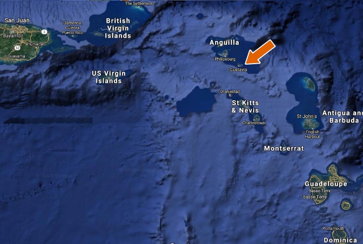
St. Barths' coordinates: Latitude: 17° 54' 50.12" N Longitude: -62° 50' 1.87" W. St. Barths lies approximately 250 kilometres (160 mi) east of Puerto Rico and southeast of the islands of Saint Martin and Anguilla. St. Barths is separated from Saint Martin by the Saint-Barthélemy Channel. It lies northeast of Saba and St. Eustatius, and north of St. Kitts.
Girls with long hair remember to pack a hair band or head scarf when you go out day/night. Some islands are more windy than others. It can be a pain in the neck - literally!


